
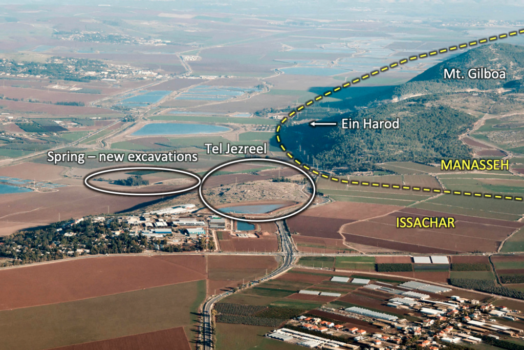
Jezreel
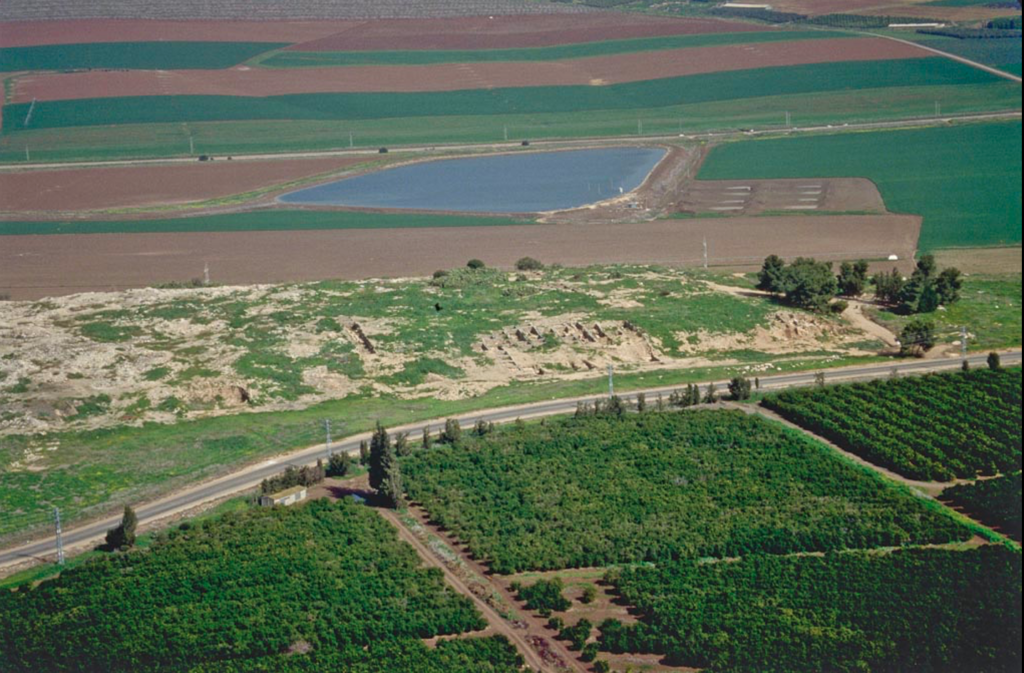
The meaning of “Jezreel” (יִזְרְעֶאל, yizre’e’l; LXX Ιεζραελ) appears to be either “God sows” or “may God make fertile/fruitful.” Jezreel sits opposite Shunem (1 Samuel 28:4; 2 Kings 4:8–10) and near halfway between Megiddo and Bethshan/Beth-shean with each being about ten miles distant from Jezreel. The junction of the Via Maris and the Way of the Patriarchs (going south from Jezreel through the central highlands to Samaria and eventually to Jerusalem) seems to have been one reason for establishing the ancient city on this site. It belonged to the tribe of Issachar as one of its border towns. Jezreel sits at the foot of Mt. Gilboa (Joshua 19:18) on the west side of the Way of the Patriarchs that runs south between the city and Mt. Gilboa. Jezreel’s spring sits in the Jezreel Valley at one and a half feet below sea level. The city tell rises over 300 feet above the valley floor and the spring.
Most biblical scholars identify biblical Jezreel with Zerin (a.k.a. Tell Yizra’al) on the southern edge of the eastern end of the Jezreel Valley. Zerin quite logically and phonetically preserves the original name. In his discussion of the toponomy of place names in ancient times and modern times, Yohanan Aharoni explains that the initial yod and its vowel tend to drop off, the aleph tends to drop out of the middle of a name, and the final lamed is prone to shift to n, as also Bethel became Beitin.[1]
David and his men camped by the spring at Jezreel (‘Ein Jezreel on the valley floor below Tell Jezreel) when Achish mustered his army at Aphek (most likely Tel Ras el-‘Ain at the headwaters of the Yarkon River) in preparation for entering battle against Saul on Mt. Gilboa (1 Samuel 29). That’s when Achish’s commanders objected to having David with them and Achish dismissed David.
During Solomon’s reign, Jezreel belonged to the fifth district of the twelve he established (1 Kings 4:12). After the divided kingdom, Jezreel became one of the capitals of the Northern Kingdom of Israel under Ahab (1 Kings 18:45), who chose it as the site for his winter palace. After Elijah slew the prophets of Baal on Mt. Carmel (1 Kings 18), he ran ahead of Ahab’s chariot all the way back to Jezreel (1 Kings 18:46). Naboth owned a vineyard in Jezreel that Jezebel coveted and connived to obtain (1 Kings 21:1–10). When the dynasty of Ahab came crashing down, his descendants’ blood flowed at Jezreel (2 Kings 10:7, 11) in accord with the prophecy of Elijah (1 Kings 21:23–24). Jehu put an end to the dynasty of Omri when he slew Joram, Jezebel, 70 sons of Ahab, and the king of Judah, Ahaziah (2 Kings 9:1–10:11).
The prophet Hosea, at the Lord’s command, names his firstborn son Jezreel (Hosea 1:4). Hosea spoke of Jezreel as representative of both Israel’s dispersion and the destruction of their power because of their disobedience and idolatry (Hosea 1:4–5). He also prophesied of Israel’s return (“resowing”) into the land after being purged of idolatry by divine judgment (Hosea 2:22–23).[2]
When the Assyrians invaded Israel in 722 BC, they destroyed Jezreel. During the Hellenistic and Roman periods Jezreel was the site of a village named Esdraelon/Esdraela (cf. Judith 3:9 and 7:3; used also as an alternative name for the Jezreel Valley).
Archaeology
David Ussishkin (University of Tel Aviv) and John Woodhead (British School of Archaeology) excavated Tel Jezreel 1990–1995. They uncovered a large, rectangular, fortified area from the ninth century BC that might date as early as Omri, but certainly to the later reign of Ahab. Some ruins beneath the ninth century level indicate an earlier occupation on the site from the tenth century BC. Since the city appears to cease its existence, some scholars suggest its destruction by the Arameans before the end of the century. Ceramic evidence indicates an occupation in the Early Bronze III (2750–2300) as well as in the Late Bronze Age (1550–1150 BC). Israelite occupants remained on the partially destroyed site until the seventh centuries BC.
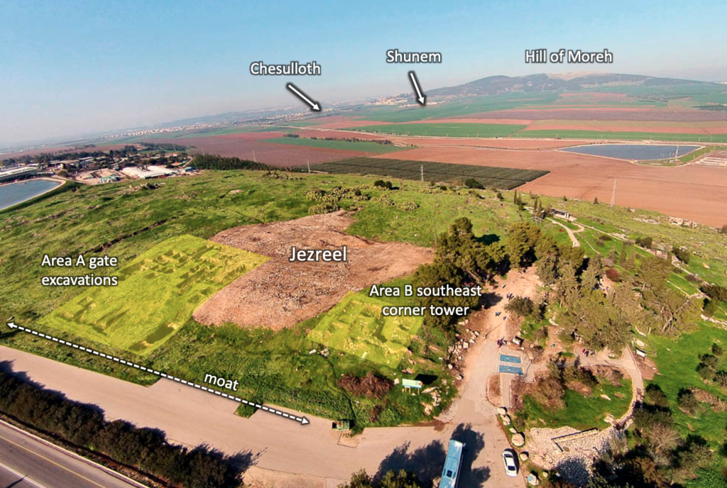
More recently, Norma Franklin and Jennie Ebeling with the Jezreel Expedition (University of Haifa and the University of Evansville, Indiana) began in 2012. They started with both an aerial survey of Tell Jezreel and ‘Ein Jezreel using LiDAR (Light Detection and Ranging; see NEA article in Recommended Resources below) and a surface survey with teams on the ground. Very quickly they discovered and identified 361 features (mostly undocumented in previous excavations). These features included “25 cave tombs, 35 rock-cut tombs, 57 agricultural installations, 21 ancient quarries, 94 walls of unknown date, 26 natural caves that had been adapted for animal use, and nearly 100 cisterns.”[3] Cisterns, tombs, and silos present many potential dangers for walking over the surface of the tell — some cisterns are nearly 50 feet deep. Barbed wire fencing surrounds the tell and metal grating has been placed over some of the deeper holes in the limestone bedrock. Visitors are advised to stick to the walkways. Heavy overgrowth of grasses and cacti easily conceal some of the features.
Administrative complex. The rectangular enclosure comprises an area of about eleven acres (approx. 860 feet long and 470 feet wide). In all four corners of this administrative complex the builders placed towers projecting from the wall (southwest, northwest, northeast, and southeast). The last of these towers presented evidence of destruction by fire (it sits a little southwest of the grove of trees near the parking area). It’s not certain why the destruction by fire appears to be limited to the one tower. The northeastern tower looks down the Harod Valley toward the hills of Gilead in Transjordan. Elijah anointed Jehu king in Gilead (2 Kings 9:1–10). Perhaps the “watchman” who first caught sight of Jehu’s approaching forces stood on that tower (2 Kings 9:14–20).
Three features indicate the administrative and military function of this enclosure: (1) Its strong fortifications with casemate walls, projecting towers, and moat, (2) the utilitarian structure, unconcerned with esthetics, employees a minimum of ashlar, and (3) the effort it took to level this large of a site for construction of the enclosure.[4]
Moat. Running around three sides of the complex was a moat (20 feet deep and 25–35 feet wide) and narrowing to but 24 feet in the vicinity of the gate. No moat would have been needed above the steep slope of the northern side. Indeed, builders situated the city gate in the south wall, because the northern wall’s slope fell away steeply into the Jezreel Valley. Jehu ordered the heads of Ahab’s seventy descendants arranged in two piles at this gate (2 Kings 10:8).
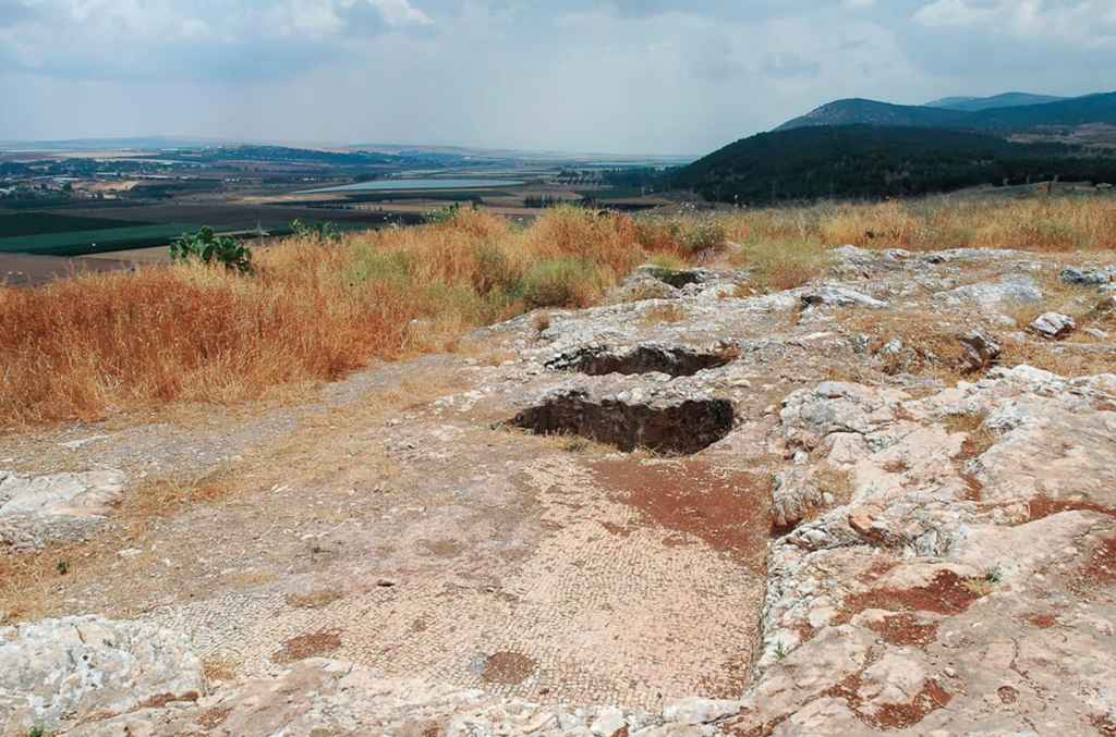
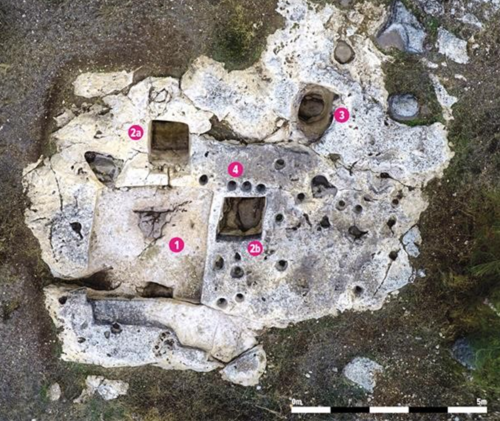
Winery. A winepress (rectangular flat area in foreground) and accompanying installation (one or two vats) on the northeast section of Tell Jezreel can be seen in the photo above. Ussishkin and Woodhead excavated that installation in the early 1990s. The Jezreel Expedition’s excavations in 2013 worked in Area K that appears to be a little lower down the northeastern slope of the tell and separated from ‘Ein Jezreel by a lower cultivated area. The archaeological team uncovered a large winery complex. The installation includes a treading floor, two vats, a basin, and a number of mortars or pits.
The excavated winery complex covers approximately 130 square feet and consists of a treading floor 34 square feet and two vats each c. 14 square feet and more than 3 feet deep.
It is not easy to date ancient rock-cut wineries. During periods of use, any pottery or other artifacts that help date archaeological contexts would have been cleared away on a regular basis so as not to interfere with wine production. Therefore, we are primarily dependent on comparisons with other wineries in order to establish the date of its construction.
Gösta W. Ahlström conducted an extensive survey of 117 wineries in the area southwest of Jezreel and found that most of them consisted of a rectangular treading floor connected to a rectangular vat. However, since stone cutting methods do not significantly change over time, these installations are difficult to date. In addition, they could have been used for hundreds or even thousands of years. Fortunately, we were able to obtain a few samples of plaster from the treading floor that yielded carbonized material that could be radiocarbon dated; the results revealed that the plastered surface—which dates the final use of the treading floor—dates to sometime from the mid-first century B.C.E. through the mid-first century C.E. But when was this winery first cut?
— Norma Franklin, Jennie Ebeling, Philippe Guillaume, and Deborah Appler, “Have We Found Naboth’s Vineyard at Jezreel?” Biblical Archaeology Review 43, no. 6 (2017): 53–54
Placing the winery in close proximity to the administrative-military enclosure on Tell Jezreel makes sense. Wine production and storage for an Israelite army or a later Assyrian contingent would prove to be a beneficial arrangement. The Jezreel Expedition dates the enclosure to the eighth century — perhaps during the reign of Jeroboam II (789–748 BC). “Following the fall of the Northern Kingdom of Israel under Sargon II, Jezreel’s strategic location meant that it could well have functioned as a bēt mardēti, a small, exclusively Assyrian fort for muster and provision.”[5] Since such installations tend to be reused over a long history, the winery facility connected to a military presence on the tell very well may have continued on into the Byzantine period.
Recommended Resources
- Ebeling, Jennie, and Norma Franklin. “Jezreel Expedition 2016: Jezreel through Time.” Bible History Daily, Biblical Archaeology Blog, July 7, 2016.
- Ebeling, Jennie, Norma Franklin, and Ian Cipin. “Jezreel Revealed in Laser Scans: A Preliminary Report of the 2012 Survey Season.” Near Eastern Archaeology 75, no. 4 (December 2012): 232–39.
- Franklin, Norma, and Jennie Ebeling. “Archaeological Views: Returning to Jezreel.” Biblical Archaeology Review39, no. 3 (2013): 28, 70.
- Franklin, Norma, and Jennie Ebeling. “Preliminary Report of the 2013 Jezreel Expedition Field Season.” The Bible and Interpretation Blog, August 2013.
- Franklin, Norma, and Jennie Ebeling. “Preliminary Report of the 2015 Jezreel Expedition Field Season.” The Bible and Interpretation Blog, September 2015.
- Franklin, Norma, Jennie Ebeling, Philippe Guillaume, and Deborah Appler. “Have We Found Naboth’s Vineyard at Jezreel?” Biblical Archaeology Review 43, no. 6 (2017): 49–54.
- Franklin, Norma, Jennie Ebeling, Philippe Guillaume, and Deborah Appler. “An Ancient Winery at Jezreel, Israel.” Journal of Eastern Mediterranean Archaeology & Heritage Studies, vol. 8, no. 1 (2020): 58–78. Available at JSTOR.
- Korpel, Marjo C. A. “Fit for a Queen: Jezebel’s Royal Seal.” Biblical Archaeology Review 34, no. 2 (2008): 32, 34–37.
- Ussishkin, David. “Jezreel—Where Jezebel Was Thrown to the Dogs.” Biblical Archaeology Review 36, no. 4 (2010): 32–42, 75–76.
- Zelig Aster, Shawn. “The Function of the City of Jezreel and the Symbolism of Jezreel in Hosea 1–2.” Journal of Near Eastern Studies 71, no. 1 (2012): 31-46.
Footnotes
[1] Yohanan Aharoni, The Land of the Bible: A Historical Geography, trans. by A. F. Rainey (Philadelphia: Westminster Press, 1967), 110–11.
[2] George J. Zemek and J. Todd Murray, Love Beyond Degree: The Astounding Grace of God in the Prophecies of Hosea (The Woodlands, TX: Kress Biblical Resources, 2017), 30–31, 52–53, 60. See, also, Douglas Stuart, Hosea–Jonah, Word Biblical Commentary 31 (Nashville, TN: Thomas Nelson Publishers, 1987), 28–30, 39–40, 60–61.
[3] Norma Franklin and Jennie Ebeling, “Archaeological Views: Returning to Jezreel,” Biblical Archaeology Review 39, no. 3 (2013): 70.
[4] Shawn Zelig Aster, “The Function of the City of Jezreel and the Symbolism of Jezreel in Hosea 1–2.” Journal of Near Eastern Studies 71, no. 1 (2012): 37.
[5] Norma Franklin, Jennie Ebeling, Philippe Guillaume, and Deborah Appler. “An Ancient Winery at Jezreel, Israel.” Journal of Eastern Mediterranean Archaeology & Heritage Studies, vol. 8, no. 1 (2020): 74. Available at JSTOR.
Note: The owner of this website receives a small commission on sales of books from Amazon.com by means of the links supplied for those books. This applies only to the books cited in the footnotes above.