Medeba
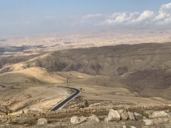
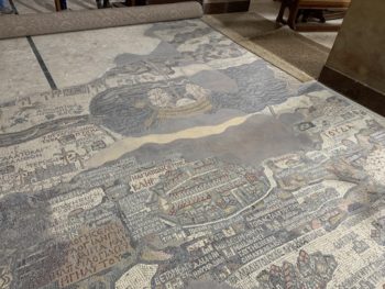
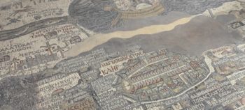
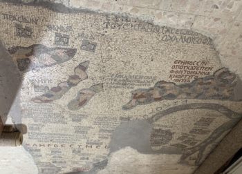
Scripture refers to Medeba in lists of cities seized by the Israelites (Numbers 21:30; Joshua 13:9, 16). Joab, during David’s reign, fought the Amorites and Ammonites at Medeba (1 Chronicles 19:6–15). About 150 years later, King Mesha of Moab (see 2 Kings 3:4) erected a stela (the Moabite Stela) mentioning how Omri had taken Medeba, but Mesha had liberated it from Jehoram (2 Kings 3:27). The city sits on the King’s Highway about 18 miles south of Amman. The city has become best known for the mosaic map discovered in 1897 on the floor of a 6th century AD church. To date, it represents the earliest known map of Israel and her surroundings. The map originally covered the eastern Mediterranean world from Byblos, Syria in the north to Thebes, Egypt in in the south. Greek labels appear to follow Eusebius’ descriptions in his Onomasticon. The map’s size must have been about 51 feet long and a little over 18 feet wide. Around 150 place names survive in the current map, which is not complete. As with modern maps of Israel, the Medeba map is oriented toward the east. While the map gives the approximate locations of cities, the creators placed them along the ancient highways or routes for trade and travel.
Mt. Nebo
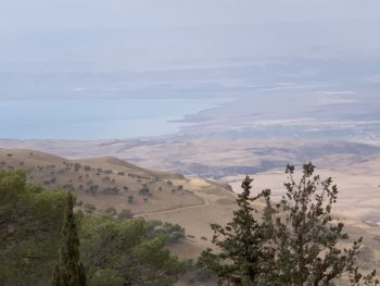
Mount Nebo is a peak in the Abarim mountain range in Moab sitting opposite and east of Jericho (Deuteronomy 32:49; 34:1, 4). The range lies northeast of the Dead Sea and forms the northwestern rim of the Moab plateau. The peaks of Abarim rise about 600 feet above the plateau. The Dead Sea lies about 4,000 feet below their summits. The Israelites camped there (Numbers 33:47) and Moses viewed the land of Canaan before he died there (Numbers 27:12; Deuteronomy 32:49). When I visited Mt. Nebo twenty-one years ago, we could barely make out the west side of the Jordan River due to the haze. On this visit, some rain and wind gave us a little clearer view.